History
Fort Apugan started its structure in the late 1700's and was finalized in the early 1800's, was chosen by Governor Manuel Muro.
This fort is also known as Fort Santa Agueda, named after Muros wife, "Maria Agueda Del Camino."
Governor Manuel Muro chose this Fort for tactical purposes in World War II. Tactical purposes such as good defense from intruders coming in from the bay and to keep the villages safe.
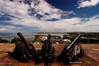
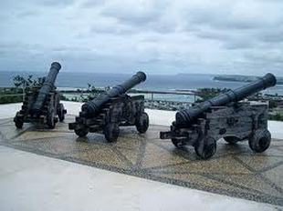
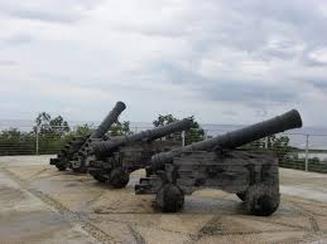
There were originally ten cannons present on the fort, but now only three replica cannons remain.
In the 1900's, Fort Apugan was used as a signal station to detect American ships. The fort was clear at the year of 1930, but during World War II, the Japanese saw the strategic location of the fort, and built a gun emplacement.
This fort is also known as Fort Santa Agueda, named after Muros wife, "Maria Agueda Del Camino."
Governor Manuel Muro chose this Fort for tactical purposes in World War II. Tactical purposes such as good defense from intruders coming in from the bay and to keep the villages safe.
There were originally ten cannons present on the fort, but now only three replica cannons remain.
In the 1900's, Fort Apugan was used as a signal station to detect American ships. The fort was clear at the year of 1930, but during World War II, the Japanese saw the strategic location of the fort, and built a gun emplacement.
|
|
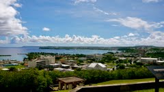
Overlooking Hagåtña Fort Santa Agueda, the only surviving Spanish fort in Hagåtña, sits atop Apugan Hill on the western coast of Guam. The fort now commonly called Fort Apugan, provides a commanding view of the capital village of Hagåtña, the Philippine Sea, and the sheer northern clifflines of Oka Point and Urunao Point. The fort is also in a prime location to study the northern topography of the island with its raised limestone plateau. During the Spanish era, however, the site was developed for tactical purposes.
One of the earliest historical references to the fort was written by William Haswell, in 1802. Haswell, a Spanish-speaking first officer aboard the chartered American whaler, Lydia, reported seeing seven cannons and 10 men stationed at the fort. Shots were fired from the fort as a salute when Vicente Blanco, the Spanish governor who replaced Muro, first entered the church in Hagåtña.
One of the earliest historical references to the fort was written by William Haswell, in 1802. Haswell, a Spanish-speaking first officer aboard the chartered American whaler, Lydia, reported seeing seven cannons and 10 men stationed at the fort. Shots were fired from the fort as a salute when Vicente Blanco, the Spanish governor who replaced Muro, first entered the church in Hagåtña.
|
The fort was equipped with embrasures for ten small cannons, which were faced toward the Hagåtña Bay channel. Muro selected Apugan Hill as a fortification site to protect the low lying Governor’s Palace and Fort San Rafael, which were prone to hillside assaults. Spanish governors were concerned with the possibility of English privateers pillaging the colony or capturing vessels involved with the lucrative galleon trade.
|
|
Forts not needed after Galleon trade falls off Throughout the 19th century Spanish governors had a difficult time maintaining Guam’s fortifications. The end of the galleon trade about 1815 – due primarily to the Mexican Revolution – brought economic hardships to Guam as supplies and finances became scarce. Spain was no longer benefiting from Mexico’s silver and the nation had incurred a tremendous war debt.
In 1817 Russian commander Otto von Kotzebue, aboard the Rurik, reported that Santa Agueda had only a few guns with no powder. In 1853 Governor Felipe de la Corte reported that the fort had the capacity to house fifty pieces of artillery, but was scarcely protected except for a nine-foot railing. In 1871 Governor Louís de Ibáñez y García judged the fort to be useless and in 1887 Governor Francisco Olive y García also questioned the fort’s effectiveness.
Americans use as a signal stationDuring the early American era, the fort was used as a signal station for ships. In 1933 the area was cleared, a road was constructed and it was proclaimed a naval government park. In 1942, during the Second World War, the Japanese recognized the strategic location of the fort and built a gun emplacement on the site. Japanese characters can still be observed embedded in the concrete.
Currently the site belongs to the government of Guam and is maintained by the Department of Parks and Recreation. All that remains of the fort is a raised viewing platform, but the site is one of the most frequently visited parks by tourists given its unobstructed view of Guam’s scenic western coast.